Cyclone Bola
- When
- 6 March 1988 – 9 March 1988
- Where
- Gisborne · Tūranganui-a-Kiwa
- Reach
- Several regions
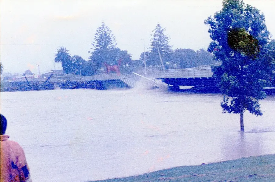
Over 900 millimetres of rain fell on the East Coast in three days, stripping hillsides and cutting the region off. At least three people died.
Some of the North Island's eastern hills are made of soft, geologically young sediment. Stripped of forest and turned into pasture by settlers, these slopes of siltstone, known as papa, are prone to erosion. Settlers soon saw what heavy rain could do: after torrential rain near Gisborne in December 1893, the school inspector Henry Hill found 'thousands of breakaways or slips'. Bola began as a tropical cyclone far to the north. It formed on 24 February 1988 north of Fiji and, tracking generally south-west, reached hurricane-force winds near Vanuatu on 28 February. In Vanuatu its heavy rain destroyed two bridges and caused severe damage across the islands. It then weakened as it moved south, and on 4 March it became an extratropical storm.
From about 6 March Bola's remnants began to affect the North Island with strong easterly winds. The storm slowed as it moved over Hawke's Bay and Gisborne–East Cape, bringing more than three days of torrential rain. Worst hit was the hill country inland from Gisborne, where strong winds forced warm, moist air up and over the hills. In places more than 900 millimetres fell in 72 hours, and one locality had 514 millimetres in 24 hours, more than parts of Central Otago get in an average year. The floods overwhelmed river stopbanks, damaged houses, swept away bridges and sections of road and railway line, and destroyed parts of Gisborne's main water-supply pipeline. Te Ara records that thousands were evacuated, among them 3,000 in Gisborne, 300 in Wairoa and 400 at Te Karaka; Wikipedia gives 500 at Te Karaka. Te Ara and NZHistory record three deaths, of people whose car was swept away by floodwaters; Wikipedia, citing NIWA, gives seven people drowned.
The rain set off innumerable landslides on hillside pasture. Some farmers lost 30 percent of their grazing land, and the scars took decades to heal. One 11,000-hectare catchment alone deposited a million tonnes of sediment into the Waipāoa River. Thick sediment from the receding floods smothered pastures, orchards and crops ready for harvest. The damaged crops included 3,000 tonnes of grapes, 7,000 tonnes of sweetcorn and 13,500 tonnes of tomatoes, and so much produce was swept into the sea that fishing boats were dredging fruit from the sea floor for months. On 8 March the Minister of Civil Defence, Michael Bassett, flew to Gisborne in an air force plane, as the airport was closed to normal passenger flights, to organise water and food supplies. On 11 March the prime minister, David Lange, flew by air force helicopter north of Gisborne with a mission dropping supplies to stranded people. Te Ara and NZHistory both put losses to horticulture and farming at $90 million, and the cost to the government at around $112 million (NZHistory says more than $111 million). Te Ara's East Coast region entry gives a lower figure of around $60 million in damage.
Te Ara counts Bola among the most damaging cyclones to have hit New Zealand in the last two centuries. Soft, dissected hill country of this kind was badly affected. Of about $80 million the government provided to the region, Wikipedia records, $8 million went to set up an East Coast forestry conservation scheme to protect forests and prevent erosion. Te Ara notes that some 320 square kilometres were reforested through the East Coast forestry project, begun in 1992, and that by 1994, as hill-country farming struggled to remain profitable, East Coast land capable of supporting around 150,000 stock units had been converted to forestry. Debate continued over whether such land should still be farmed or planted in trees to stabilise the slopes. The effects on people lasted too: a study five years after the storm of 112 people who had been evacuated or received assistance found 12 percent experiencing post-traumatic stress disorder. The name Bola was retired, so it will not be used again for a South Pacific cyclone. In February 2023 Cyclone Gabrielle surpassed Bola's death toll and economic cost.
The defining moments of New Zealand, on one poster. Get your digital print for $25
Regions affected
Sources
Written for this project from these references rather than copied from them. Follow a link to read the full account, or to check this one against the original.
Related
The Hawke’s Bay earthquake
A magnitude 7.8 quake devastated Napier and Hastings and killed 256 people — still New Zealand’s deadliest earthquake.
NapierThe influenza pandemic
About 9,000 people died in two months — roughly half as many as died in four years of war. Māori died at more than eight times the Pākehā rate.
The 28th (Māori) Battalion
Te Hokowhitu-a-Tū
A volunteer battalion organised by tribal area fought in Greece, Crete, North Africa and Italy. Its casualty rate was almost 50% above the average for New Zealand infantry battalions.
Te reo Māori becomes an official language
Te Ture mō Te Reo Māori
Te reo Māori gained official status and the right to be spoken in court, fifteen years after the language petition and following a Waitangi Tribunal finding that it was a taonga.